
Crashfree India School Safety Index DELHI · JAIPUR · PUNE

Schools / Pune

Road-environment audit · SSI v0.3

The road outsideShri Swami Samarth New Semi English School

414, Anandrao Lande Road, Indrayani Nagar Sector 2, Bhosari, Bhosari, Pimpri-Chinchwad, Maharashtra 411026, India18.63229, 73.84027audited 2026-08-06
24/100
Unsafeprovisional band
Unsafe. Very little on this road protects a child crossing to the gate.
Of the five things we check, 3 are missing entirely.
This road · 24
0 · no protectioncomplete protection · 100
Checked twice, independently
Two AI readers on separate accounts · corrections logged in public
5
Confirmed
0
Corrected
0
Unresolved
See how each was judged
Of 153 roads scored so far, this one ranks 134 (worst first). The others scored between 0 and 41.
23.75points earned
/
70.5points we could see (70%)
=
33.7%provision
×
0.7exposure — arterial
=
23.6provision × exposure
→
24SSI · rounded to nearest · v0.3

Only what the imagery could actually resolve is scored (70% of the rubric here); the rest is left uncounted rather than guessed. A road with full protective infrastructure scores near 100.

The road in context · derived from public data

Where this road sits

Before the checks: what kind of road this is, how it meets other roads, and what passes it. These lines describe the road and its surroundings — they do not change the score.

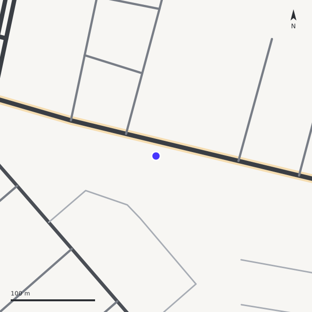
Road layout around the gate, drawn from OpenStreetMap
Road layout · drawn from OpenStreetMap · blue dot = school coordinate
FrontageThe gate opens onto an arterial road (Anandrao Lande Road), on its S side
Junctionthe gate area sits at a 3-leg junction
Street activity3 mapped shops within 150 m (OpenStreetMap)
Crash recordcrash-location data is not yet available for Delhi — this line will be added when a public source lands
Exposure contextElevated — 51/100 (partial: no crash component yet). Describes how much traffic and crash risk passes this road — context only, never part of the road score (method: exposure v1, Data page)

Road layout data © OpenStreetMap contributors (ODbL), retrieved 13 Aug 2026 · crash data: Jaipur Police · derivations: `exposure_v1` on the Data page.

What we found · five checks · IRC:SP:32-2023

Five things we checked — and the photo behind each

Each check was read once, then verified blind by a second reader on a separate account. The photo each finding came from sits right beside it. Tap “see how this was judged” for the full reasoning.

✕
Slowing traffic downP1 · Physical speed control

Nothing slows traffic at the gate

No speed hump, table or rumble strip on the approach — vehicles reach the gate at full speed.

Absent
Also cited for this check
0 of 30 points
LevelNone (L0)
Points0 of 30
ConfidenceHigh
Coverage seen≈75%
VerificationConfirmed — both readers agreed
The full reasoning

Long clear views along both approaches of the frontage show plain asphalt with a painted centreline only: no humps, raised tables, rumble strips or transverse bar markings anywhere in the visible zone.

✕
Getting across the roadP2 · Safe crossing

No safe place to cross

No marked or raised pedestrian crossing at or near the gate.

Absent
Also cited for this check
0 of 25 points
LevelNone (L0)
Points0 of 25
ConfidenceHigh
Coverage seen≈70%
VerificationConfirmed — both readers agreed
The full reasoning

No zebra or other marked pedestrian crossing, raised crossing, or signal visible on any observed stretch of the frontage or approaches; a pedestrian is seen crossing mid-carriageway on unmarked asphalt in VIXtchof94Do_h283_f90_road.jpg.

✓
Walking without stepping into trafficP3 · Footpath & separation

Footpaths on both sides

A continuous walking edge runs along both sides of the frontage.

Present
Also cited for this check
18.75 of 25 points
LevelGood (L3)
Points18.75 of 25
ConfidenceHigh
Coverage seen≈70%
VerificationConfirmed — both readers agreed
The full reasoning

Raised paver-block footpaths with black-yellow painted kerbs run continuously along both sides of the frontage in multiple consistent views (school side along the mural wall; opposite side along the bridge/canal parapet). No permanent built obstructions or breaks seen on the observed stretches. No guard-rail or bollard line separating footpath from carriageway, and no crossing exists, so L4 not met. Portable toilet cabins occupy part of the opposite footpath in one view - movable, not scored (see observations).

✕
Being seen and expectedP4 · Signage & zone identity

No school-zone signs

Drivers get no warning that a school gate is here.

Absent
Also cited for this check
0 of 10 points
LevelNone (L0)
Points0 of 10
ConfidenceMed
Coverage seen≈60%
VerificationConfirmed — both readers agreed
The full reasoning

No school warning sign, speed-limit sign, carriageway speed stamp, or 2023 zone-identity asset visible on either approach. One small white board on a pole in Z5RtBz0t-weD_h283_f90_road.jpg is unreadable at this resolution and cannot be credited; small signage could fall below image resolution, hence MED.

◑
The gate itselfP5 · Gate environment

Space and a railing at the gate

A clear setback or railing gives room to gather off the carriageway.

Partial
Also cited for this check
5 of 10 points
LevelBasic (L2)
Points5 of 10
ConfidenceHigh
Coverage seen≈70%
VerificationConfirmed — both readers agreed
The full reasoning

Compound gateway is set behind a raised kerbed footpath roughly 2 m deep with wall/railing sections, giving off-carriageway assembly space (people are seen assembled there off the roadway). No separate pedestrian wicket opening is resolvable in the gate zooms and no continuous rail runs gate-to-crossing (no crossing exists), so L3 not met. No marked pick-up/drop-off bay visible.

At the gate
On the frontage road
Along the street
Some captures sit on neighbouring lanes; older ones are shown greyed and were used only for context.
What must be fixed · 5 actions

What would make this road safe — and who owns each fix

Each action maps to a failing check, the relevant IRC:SP:32-2023 clause, and the responsible agency. Agency labels are provisional and correctable through the dispute channel.

01Lifts P1

Install a speed table or twin speed humps within 30 m of the gate

IRC:SP:32-2023 §5.13 · Table 5.1MCD / PWD · provisional

Speed humps near schools roughly halve child-pedestrian injury odds (Tester 2004); 30 km/h calmed zones ≈ 40% fewer casualties (Grundy 2009).

02Lifts P2

Mark a crossing within 20 m of the gate — table-top preferred

IRC:SP:32-2023 §5.4.3MCD / PWD · provisional

Raised crossings cut vehicle speeds at the exact conflict point.

03Lifts P4

School-zone warning signs on both approaches with the speed limit

IRC:SP:32-2023 §5.8MCD / PWD · provisional

The zone must announce itself to drivers before the gate.

04Lifts P3

Provide a continuous clear walking edge on the school side

IRC:SP:32-2023 §5.4.1MCD / PWD · provisional

A continuous footpath keeps children off the carriageway on the approach, not only at the gate.

05Lifts P5

Add space and a marked pick-up bay off the carriageway at the gate

IRC:SP:32-2023 §5.2MCD / PWD · provisional

Children should not step from the gate into a moving traffic lane.

Responsible-agency labels come from the CFI field instrument’s mapping and are correctable via the dispute channel.

Re-audit timeline

2026-08-06Audited
2027-02-06Re-audit due

Every published road is re-read every six months, or as soon as new Street View imagery lands, or on a sustained dispute.

Something wrong on this page?

The entrance, the imagery, a finding — if any of it is wrong, tell us. A dispute pauses this page while the audit is re-verified, and the correction is logged in the public record.

Dispute this audit