
Crashfree India School Safety Index DELHI · JAIPUR · PUNE

Schools / Jaipur

Road-environment audit · SSI v0.3

The road outsideOld Govt. Secondary School Daulatpura

3RJJ+P3X, Daulatpura, Rajasthan 303805, India27.08186, 75.83023audited 2026-08-09
7/100
Critically unsafeprovisional band
Critically unsafe. Almost nothing on this road protects a child from traffic on the way to the gate.
Of the five things we check, 4 are missing entirely.
This road · 7
0 · no protectioncomplete protection · 100
Checked twice, independently
Two AI readers on separate accounts · corrections logged in public
4
Confirmed
1
Corrected
0
Unresolved
See how each was judged
Of 153 roads scored so far, this one ranks 61 (worst first). The others scored between 0 and 41.
5points earned
/
75.5points we could see (76%)
=
6.6%provision
×
1exposure — local
=
6.6provision × exposure
→
7SSI · rounded to nearest · v0.3

Only what the imagery could actually resolve is scored (76% of the rubric here); the rest is left uncounted rather than guessed. A road with full protective infrastructure scores near 100.

The road in context · derived from public data

Where this road sits

Before the checks: what kind of road this is, how it meets other roads, and what passes it. These lines describe the road and its surroundings — they do not change the score.

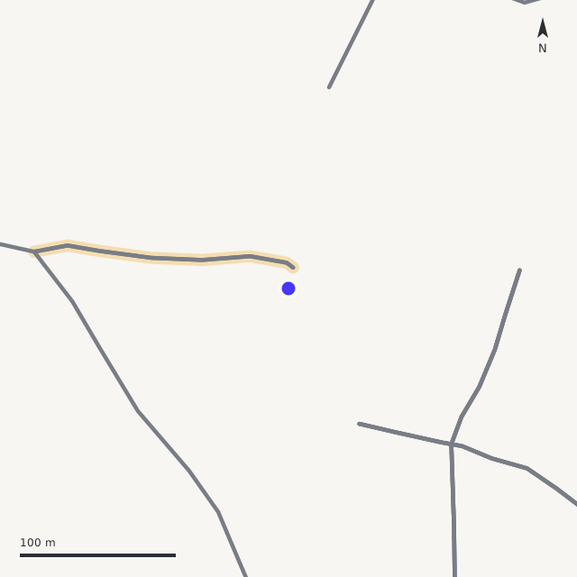
Road layout around the gate, drawn from OpenStreetMap
Road layout · drawn from OpenStreetMap · blue dot = school coordinate · red = fatal-crash points (Jaipur Police)
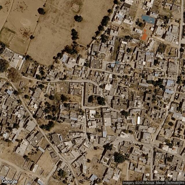
Satellite view of the same area© Google
Satellite · © Google · retrieved 2026-08-13 (capture date not published by the imagery API)
FrontageThe gate opens onto a local street, on its SW side
Junctionno junction within 120 m of the gate — a mid-block frontage
Street activityno bus stop or shops mapped within 150 m (OpenStreetMap)
Crash record8 road deaths within 500 m of the gate; 5 of the recorded crashes fell on school days, 7 am–6 pm (Jaipur Police crash data)
Exposure contextModerate — 35/100. Describes how much traffic and crash risk passes this road — context only, never part of the road score (method: exposure v1, Data page)

Road layout data © OpenStreetMap contributors (ODbL), retrieved 13 Aug 2026 · crash data: Jaipur Police · derivations: `exposure_v1` on the Data page.

What we found · five checks · IRC:SP:32-2023

Five things we checked — and the photo behind each

Each check was read once, then verified blind by a second reader on a separate account. The photo each finding came from sits right beside it. Tap “see how this was judged” for the full reasoning.

✕
Slowing traffic downP1 · Physical speed control

Nothing slows traffic at the gate

No speed hump, table or rumble strip on the approach — vehicles reach the gate at full speed.

Absent
Also cited for this check
0 of 30 points
LevelNone (L0)
Points0 of 30
ConfidenceHigh
Coverage seen≈75%
VerificationConfirmed — both readers agreed
The full reasoning

No speed humps, speed tables, rumble strips, raised tables or thermoplastic bumps visible on the gate frontage, the open square, or the near approach lanes. Surface is plain concrete/earth. Frontage and near approaches well covered; mid-zone only partial.

✕
Getting across the roadP2 · Safe crossing

No safe place to cross

No marked or raised pedestrian crossing at or near the gate.

Absent
Also cited for this check
0 of 25 points
LevelNone (L0)
Points0 of 25
ConfidenceHigh
Coverage seen≈75%
VerificationConfirmed — both readers agreed
The full reasoning

No marked pedestrian crossing (zebra or painted), no refuge island, at the gate frontage or on the visible approaches. Plain shared surface throughout the imaged frontage and square.

✕
Walking without stepping into trafficP3 · Footpath & separation

No footpath — children share the road

No usable walking edge; children walk in the traffic lane.

Absent
Also cited for this check
0 of 25 points
LevelNone (L0)
Points0 of 25
ConfidenceHigh
Coverage seen≈75%
VerificationConfirmed — both readers agreed
The full reasoning

No built footpath along the frontage or approach lanes. Narrow paved village lanes with unpaved earth edges and open masonry side-drains in places; the gate faces a shared open square. No continuous clear walkable edge separated from the carriageway; pedestrians observed walking on the carriageway (t5FgqA5PTk04 h096). Permanent condition, ignoring parked vehicles.

✕
Being seen and expectedP4 · Signage & zone identity

No school-zone signs

Drivers get no warning that a school gate is here.

Absent⟳ Corrected in review
MinimalNone

An independent second reader changed this — the two readings disagreed, and the evidence below settled it.

Also cited for this check
0 of 10 points
LevelNone (L0)
Points0 of 10
ConfidenceHigh
Coverage seen≈70%
VerificationCorrected in the second reading
The full reasoning

Audit read fell: no school warning traffic sign on the frontage or the four approaches in any view; only a school name board and notice/shop boards exist, none a warning sign. Obs gap: unimaged far-approach stretches. L0.

◑
The gate itselfP5 · Gate environment

Space and a railing at the gate

A clear setback or railing gives room to gather off the carriageway.

Partial
Also cited for this check
5 of 10 points
LevelBasic (L2)
Points5 of 10
ConfidenceHigh
Coverage seen≈85%
VerificationConfirmed — both readers agreed
The full reasoning

Metal gate set in a masonry compound wall opening onto a large open paved village square, giving ample off-carriageway assembly space (clear setback), not directly onto a moving carriageway. No separately identifiable pedestrian wicket and no continuous rail to a crossing confirmable at zoom; no marked pick-up/drop-off bay. Level 2 (clear setback).

At the gate
On the frontage road
Along the street
Some captures sit on neighbouring lanes; older ones are shown greyed and were used only for context.
What must be fixed · 5 actions

What would make this road safe — and who owns each fix

Each action maps to a failing check, the relevant IRC:SP:32-2023 clause, and the responsible agency. Agency labels are provisional and correctable through the dispute channel.

01Lifts P1

Install a speed table or twin speed humps within 30 m of the gate

IRC:SP:32-2023 §5.13 · Table 5.1MCD / PWD · provisional

Speed humps near schools roughly halve child-pedestrian injury odds (Tester 2004); 30 km/h calmed zones ≈ 40% fewer casualties (Grundy 2009).

02Lifts P2

Mark a crossing within 20 m of the gate — table-top preferred

IRC:SP:32-2023 §5.4.3MCD / PWD · provisional

Raised crossings cut vehicle speeds at the exact conflict point.

03Lifts P3

Provide a continuous clear walking edge on the school side

IRC:SP:32-2023 §5.4.1MCD / PWD · provisional

A continuous footpath keeps children off the carriageway on the approach, not only at the gate.

04Lifts P4

School-zone warning signs on both approaches with the speed limit

IRC:SP:32-2023 §5.8MCD / PWD · provisional

The zone must announce itself to drivers before the gate.

05Lifts P5

Add space and a marked pick-up bay off the carriageway at the gate

IRC:SP:32-2023 §5.2MCD / PWD · provisional

Children should not step from the gate into a moving traffic lane.

Responsible-agency labels come from the CFI field instrument’s mapping and are correctable via the dispute channel.

Re-audit timeline

2026-08-09Audited
2027-02-09Re-audit due

Every published road is re-read every six months, or as soon as new Street View imagery lands, or on a sustained dispute.

Something wrong on this page?

The entrance, the imagery, a finding — if any of it is wrong, tell us. A dispute pauses this page while the audit is re-verified, and the correction is logged in the public record.

Dispute this audit